Blue Ridge Parkway – Pisgah National Forest – 186 Miles – 13 Waterfalls- Maggie Valley, Franklin, Dillsboro, Cashiers, Highglands, Rosman, Brevard, Waynesville
The Land of the Waterfalls Loop motorcycle ride is a scenic and exhilarating journey through the lush landscapes of North Carolina, showcasing the beauty of numerous cascading waterfalls along the way. The LandoftheWaterfallsLoop.com is a tour of 13 roadside waterfalls on this long and scenic spectacular day ride. The motorcycle ride starts in Maggie Valley to Cherokee to Franklin, then to Highlands. Riders will be treated to winding roads, picturesque mountain views, and the soothing sounds of rushing water as they navigate this popular route. Highlands to Cashiers on to Rosman then to Brevard then onto US 276 to the Blue Ridge Parkway to NC 215 then follow it back to US 276 and into Maggie Valley. 186 miles. All day ride. With opportunities for sightseeing, hiking, and exploring charming small towns, the Land of the Waterfalls Loop offers a perfect blend of adventure and relaxation for motorcycle enthusiasts seeking a memorable two-wheeled experience in the heart of nature.
Get your souvenirs here… T-shirts, patches, pins, and more at motorcycleridershop.com


The Perfect Mountain Cabin Getaway
Dreaming of a romantic getaway in a picture-perfect Smoky Mountain log cabin? That dream comes true at Cherokee Mountain Cabins — hand-crafted one, two and three-bedroom luxury cabin rentals near Nantahala Lake. Mountainside cabins. Creekside cabins. Rustic, romantic and elegant with no shortage of creature comforts —
- Romantic Gift Packages
- Concierge
- Massage
- Hot Tub
- Pool Table
- Outdoor Fireplace
- Gourmet Kitchen
When you stay in our cabins, you’re in the middle of Western North Carolina’s great outdoor playground with whitewater rafting, zip lining, horseback riding, hiking, boating, fishing, golfing, mountain biking and scenic drives all at your doorstep.
Just above Cherokee Mountain Cabins, the beautiful Nantahala Lake is the second highest lake east of the Mississippi. And below our cabins, the Nantahala River offers world-class trout fishing and one of the south’s most popular whitewater sports venues.
Perched on the banks of a peaceful, mountain creek, Creekside Paradise is the perfect basecamp to all your adventures. Whether you’re a hiker, biker, or casual explorer, we look forward to welcoming you to our corner of the mountains here in Western North Carolina. Come relax in the hot tub, nap by the creek, hike the many scenic trails, or simply cozy up with a cup of complimentary coffee by the campfire. However you define adventure, we welcome it!
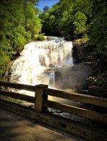
The 90 foot high Bald River Falls is recognized as one of the most spectacular waterfalls in the region. It is easily accessed from Tellico River Road (NFRS 210), and provides outstanding photographic opportunities. Parking is limited, and visitor use is high on weekends and holidays. If possible, plan your visit during weekdays.

Walhalla SC – Highlands NC – 30 Miles-3 States
The ThreeState28.com motorcycle ride Start in Walhalla, SC and head north on route 28 for 32 miles. Cross the SC/GA border, stay on route 28, cross the GA/NC border, and head into Highlands, NC. Blacktop S turns, sweepers and hairpins wind up and down the hills with glimpses of the mountains and the valleys throughout the ride along with twisties and elevation changes. This ride runs through the Sumter and Nantahala national forests with mountains, rivers and waterfalls and crossing through three states. Not a lot between Walhalla and Highlands, so, fill up before you leave Walhalla. No restaurants or other facilities for miles.
There are three rides on highway 28, the first section riding from South to North is the ThreeState28.com. This motorycle ride is 32 miles from Walhalla SC to Highlands NC, the second part is the Moonshiner 28 from Highlands NC to Franklin NC and the thrird part is TheHellbender28.com is from Franklin NC To Deals Gap NC 22 miles.
Get your souvenirs here… T-shirts, patches, pins, and more at motorcycleridershop.com
Tellico Hatchery was originally constructed by the Civilian Conservation Corps (CCC), between 1930 and 1941. It included six 25-foot circular pools and for many years was known as the Pheasant Branch Rearing Pools, because its water supply came from Pheasant Branch. Linear raceways and earthen pools, with a water source from nearby Sycamore Creek, were added in the 1940’s. More raceways were added in the 1960’s along with a water intake on Tellico River. The facility underwent major renovation in 1991-1992 and now has 28 main outdoor concrete raceways, one C-Series raceway, six concrete circular pools (not in use), a hatchery building, and two residences. Tellico Hatchery is actually a trout rearing facility (9-in. rainbow trout from Dale Hollow National Fish Hatchery are transported to Tellico where they are then reared to a larger stocking size). A brook trout hatchery building was constructed in 1991 on one of the original circular pools. Southern-strain brook trout were hatched and reared at the facility for about three years as part of ongoing brook trout restoration projects in the Tellico area. The brook trout facility is still functional but no longer in use. The facility’s current water supply comes mainly from the Tellico River, Sycamore Creek, and to a lesser extent, Pheasant Branch. Unlike other Region IV trout hatcheries (Buffalo Springs and Erwin), which have spring-fed water sources with constant year-round temperature, Tellico Hatchery water temperatures can vary from as low as 32º F in winter to 72º F in the summer. As a result, trout growth is generally very limited during mid-November through late February.
The 90 foot high Bald River Falls is recognized as one of the most spectacular waterfalls in the region. It is easily accessed from Tellico River Road (NFRS 210), and provides outstanding photographic opportunities. Parking is limited, and visitor use is high on weekends and holidays. If possible, plan your visit during weekdays.
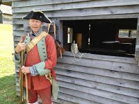
Fort Loudoun was a British colonial-era fort located in what is now Monroe County, Tennessee, United States. Built in 1756 and 1757 to help garner Cherokee support for the British at the outset of the Seven Years’ War, the fort was one of the first significant British outposts west of the Appalachian Mountains.
Fort Loudoun State Historic Park is 1,200-acres and is one of the earliest British fortifications on the western frontier, built in 1756. The fort was reconstructed during the Great Depression and was designated a National Historic Landmark in 1965.
During the French and Indian War (1754-1763) the British Colony of South Carolina felt threatened by French activities in the Mississippi Valley. To counter this threat, the Colony sent the Independent Company of South Carolina to construct and garrison what became Fort Loudoun. This move helped to ally the Overhill Cherokee Nation in the fight against the French and guaranteed the trade would continue between the Cherokee and South Carolina.
8 AM to 4:30 PM – Park Office